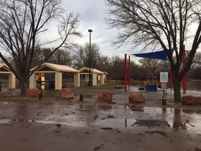
According to the city of Cottonwood Public Works Department, over the past 24-hours, the City of Cottonwood and surrounding areas have received significant rainfall. The Verde River and other waterways within the region have experienced flooding. As a result of this flooding particularly along the Verde River, portions of the city’s Riverfront Park have experienced flooding.
Currently the disc golf course, some hiking trails, in particular the Jail Trial, and the children’s play area at the northeast end of the park are impacted by flood waters and are closed for public use at this time.
 Attached to this PSA is a copy of a Flood warning and current forecast of upcoming
  weather for the region as issued by the National Weather Service on Friday, Feb. 15.
The National Weather Service is predicting more precipitation for the region over the course of this upcoming week.
 Residents should remain vigilant of their surroundings and not take any chances crossing flooded roadways.
If you have any questions, please contact: Robert L. Winiecke, Public Works director and city engineer, rwiniecke@cottonwoodaz.gov or (928) 340-2770.
National Weather Service Forecast
Isolated rain and snow showers will continue across Northern Arizona through early Friday. Any snow will generally remain confined to elevations above 8,000 to 8,500 feet. Conditions remain unsettled over the weekend with accumulating snow possible Saturday and a more significant storm arriving late Sunday into Monday.
The widespread heavy rain has ended overnight with only a few isolated rain and snow showers remaining on radar. Snow levels have fallen as predicted behind the Thursday system. They are currently hanging in around 6,000 to 6,500 feet with higher snow levels around 7,000 to 8,000 feet along the eastern Mogollon Rim.
Expected isolated rain and snow showers to continue through sunrise. Accumulations will be minor.
The Flash Flood Watch has been allowed to continue through Friday afternoon. Many areas are still experiencing flooding as runoff from Thursday`s precipitation and additional runoff from snow melt continue to cause issues in many areas. Expect most rivers will crest Friday morning into midday Friday before receding below flood levels in the afternoon. Continue to stay alert for any new Flash Flood Warnings in your area.
After a lull in activity Friday, active weather returns through the weekend. Saturday, expect a quick moving shortwave trough to bring widespread rain/snow showers across much of the area. Snow levels will be around 4000 to 5000 ft. Accumulations of 1 to 3 inches are possible for areas around Flagstaff with locally higher totals to 4 inches possible west of Flagstaff.
Along the Kaibab Plateau totals around 4-6 inches are possible. Conditions will remain showery through Sunday midday with additional minor accumulations possible above 4,000 feet.
A deeper more impactful storm is still on the horizon for Sunday into Monday. Accumulations with this storm will likely reach advisory criteria across the Mogollon Rim. Snow levels will be low around 2500 – 3500 ft with this system. Amount increased overnight with totals around 4-8 inches along the Mogollon Rim with locally higher totals and 2-4 inches possible in the lower elevation valleys through Tuesday morning. There is still some spread on amounts and timing in the models so there is not high confidence in the current totals and they are subject to change.
After Monday, weather remains unsettled and cold across the area.
Tuesday and Wednesday, only isolated snow showers will be around mainly along the high terrain. Looking out toward the end of the period Thursday and Friday, another significant winter storm continues to be a possibility in the long range models. Confidence is increasing but still low at this time. Overall, a very unsettled week across Northern Arizona. Stay tuned for updates as confidence increases.


